The Story
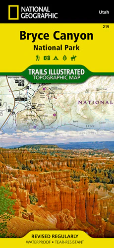
National Geographic’s Trails Illustrated map of Bryce Canyon National Park has valuable information and super detail of this unique landscape of hoodoos and forest. Created in partnership with local land management agencies, this expertly researched map will help you get the most from your visit with backpacking and day hike trail summaries, accurate road network, trailheads, campgrounds, lodging, and scenic viewpoints.
Includes Rainbow Point, Ruby’s Inn, Natural Bridge, portions of Grand Staircase – Escalante National Monument and Dixie National Forest, with an inset of Bryce Amphitheater, information on the park’s geology, natural history, weather, history and culture, regulations, and more.
Specs
- Miles of mapped trails include Great Western Trail, cross-country ski trails, and horse routes
- Mileages between intersections
- Map base includes contour lines and elevations for summits and passes
- Printed on "Backcountry Tough" waterproof, tear-resistant paper
- Full UTM grid is printed on the map to aid with GPS navigation
| Dimensions | Folded - 4.25 x 9.25 in Opened - 25.5 x 37.75 in |
| Scale | 1:40,000 & 1:20,000 |
| Last Revision | 2016 |
| ISBN # | 9781566953207 |
Description
National Geographic’s Trails Illustrated map of Bryce Canyon National Park has valuable information and super detail of this unique landscape of hoodoos and forest. Created in partnership with local land management agencies, this expertly researched map will help you get the most from your visit with backpacking and day hike trail summaries, accurate road network, trailheads, campgrounds, lodging, and scenic viewpoints.
Includes Rainbow Point, Ruby’s Inn, Natural Bridge, portions of Grand Staircase – Escalante National Monument and Dixie National Forest, with an inset of Bryce Amphitheater, information on the park’s geology, natural history, weather, history and culture, regulations, and more.
Specs
- Miles of mapped trails include Great Western Trail, cross-country ski trails, and horse routes
- Mileages between intersections
- Map base includes contour lines and elevations for summits and passes
- Printed on "Backcountry Tough" waterproof, tear-resistant paper
- Full UTM grid is printed on the map to aid with GPS navigation
| Dimensions | Folded - 4.25 x 9.25 in Opened - 25.5 x 37.75 in |
| Scale | 1:40,000 & 1:20,000 |
| Last Revision | 2016 |
| ISBN # | 9781566953207 |